|
|
|||||||||||||||||||||||||||||||||||||||||||||||||||||||||||||||||||||||||||||||||||||||||||||||||||||||
|
|
|||||||||||||||||||||||||||||||||||||||||||||||||||||||||||||||||||||||||||||||||||||||||||||||||||||||
Sharp County Regional Airport 20 Airport Lane, P.O. Box 129 Cherokee Village, AR 72529 870-257-2289
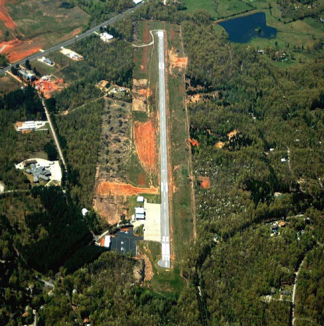
The Sharp County Regional Airport (CVK), is a publicly owned, open to the public facility operated by the Sharp County Regional Airport Authority. The airport is located 3 miles northeast of the Ash Flat city center, it occupies 42 acres. The airport is served by one runway, runway 4-22, measuring 5,156 feet in length. A turnaround is provided at the southwest end of the runway, and the apron area is located near runway 22 threshold. Runway 4 is served by two non-precision instrument approaches. A fixed base operator (FBO) at the airport provides aircraft services. Aircraft storage is provided by hangars and apron tie downs. General aviation operations include corporate, military, law enforcement, medical activities, as well as frequent recreational flying.
Operations (reported) Yearly 2150 Avg. Daily 6
Airport Data: CVK SHARP COUNTY RGNL ASH FLAT AR
Fuel Available: 100LL & JET A
Self-service fuel available 24 hours with credit card.
FAA Services Sectional Chart - KANSAS CITY No FSS on field FSS tie-in - JONESBORO Notams issued by -
JBR APCH/DEP SVC PROVIDED BY MEMPHIS ARTCC ON FREQS 120.075/289.4 (WALNUT RIDGE RCAG).
|
|||||||||||||||||||||||||||||||||||||||||||||||||||||||||||||||||||||||||||||||||||||||||||||||||||||||
|
|
|||||||||||||||||||||||||||||||||||||||||||||||||||||||||||||||||||||||||||||||||||||||||||||||||||||||